
Date: 3rd May 2010
Slieve Binnian
Classification: Dillon
Height: 747 metres
Walked previously
Wee Binnian (Minor summit)
Height: 460 metres
Moolieve (Minor Summit)
Slievenaglogh (Minor summit)
Height: 445 metres
Slieve Muck
Classification: Dillon
Height: 674 metres
Walked previously
Carn Mountain (Minor summit)
Height: 588 metres
Slieve Loughshannagh
Classification: Dillon
Height: 619 metres
Dillon Count: 32
Slieve Meelbeg
Classification: Dillon
Height: 708 metres
Dillon Count: 33
Slieve Meelmore
Classification: Dillon
Height: 680 metres
Dillon Count: 34
Slieve Bearnagh
Classification: Dillon
Height: 739 metres
Dillon Count: 35
Slievenaglogh (Minor summit)
Height: 586 metres
Slieve Corragh (Minor summit)
Height: 640 metres
Slieve Commedagh
Classification: Dillon
Height: 767 metres
Dillon Count: 36
Slieve Donard
Classification: Dillon, Hewitt, Marilyn, County-top
Height: 850 metres
Walked Previously
A wise man once told me that the definition of failure isn't to fall down; it is not to get back up again. I had waited eight long months to get back up again, a time stretching from August 23rd 2009 to 6:20am on Monday, May 3rd 2010 when I found myself at the foot of the Mourne Mountains and the start of my second attempt at the Mourne Wall Walk.
I suppose you could say that the previous attempt had not gone well... you would be pretty correct in saying that it had ended in something of abject failure and quite a bit of misery. On that occasion, the Mournes had quite simply chewed us up and spat us out again. We were the proverbial lambs to the slaughter; badly prepared, totally lacking the requisite fitness and arrogantly believing that we could triumph over whatever Nature could throw at us including the forecasted stormy weather.
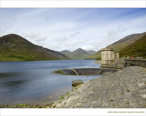
Those arrogant presumptions were given fuel as we started out from Carrick Little car-park heading towards glistening peaks which were bathing in the warmest of autumnal sunshine. The first part of that particular walk had seen the Mournes effortlessly lull us into a false sense of security, so much so that we’d even had an extended lunch break down by Silent Valley reservoir all the while untroubled by our lack of progress and completely oblivious to the ominous gathering of a melee of dark clouds overhead.
Time out on Slieve Binnian on the first attempt
Crossing Slient Valley reservoir on first attempt
Not even the discovery by one member of the party that he had left half his water supply in the car boot failed to lighten the mood. In our minds, we were Kings of the Mountains and anything that they could throw at us.
The prevailing mood began to change as we struggled up one side of Slievenaglogh and back down the other and by the time we reached the foot of Slieve Muck, the dark clouds had dropped down out of the sky and were rushing and dancing over the ground all around us.
Slieve Muck itself quite simply broke our spirit; our overfilled back-packs combined with a complete lack of visibility meant that each and every step became a mammoth task. It was only due to a now gale force wind at our backs that we managed to get to the top of Muck at all. The scene at the top was akin to Armageddon as menacing black clouds danced impetuously across its flat summit only occasionally giving way to reveal a glimpse of a forlorn looking trig pillar which appeared to be crying out for rescue.
Things went from bad to worse on the crossing from Muck to Carn. The last of the daylight ebbed away and the storm continued to pick up bringing heavy showers of rain with it. Murphy’s Law then kicked in to dictate that the walk spiraled even more in the direction of disaster; the heel of my walking boot splitting open as I tripped over a muddy rock and ended up on my backside.
We spent a very uncomfortable night camped to one side of the wall taking whatever shelter we could from the raging storm, our tents fiercely battered by the winds and occasionally threatening to pull free from their stakes. The next morning saw the storm still raging leaving us with no option but to abandon the walk. We downheartedly descended off the mountains and spent the long and miserable walk back by road to the car-park at Carrick Little with the bitterest taste of failure in our mouths.
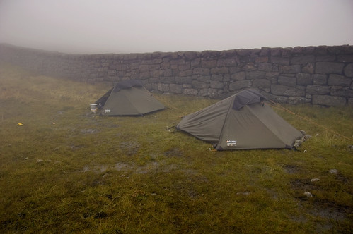
Base-camp! Camped out on the original attempt
Failure…. Abject Failure! It didn’t sit well with me over the winter months. Spurred on by that failure, I took up jogging and spent much of the winter building up my fitness levels to tackle the Wall again when the weather got better and the days got longer. Several people accused me of succumbing to some kind of mountain-related madness and there was probably more than a bit of substance in those accusations.
And so, at 6:20 am on the morning of May 3rd, I found myself starting out again from Carrick Little car-park on the road to redemption.
This time I had packed light, a pair of Inov8 trail running shoes had been broken in on some shorter walks and on my back was a Camelbak Alpine Explorer pack which has an integrated 3 litre hydration reservoir. Instead of doing the walk over two days and having to carry overnight gear, I decided to do it over one long day. The good people at Mapyx Quo had provided me with an electronic copy of the Mournes Maps and their software had proved invaluable in allowing me generate a very detailed route card to download to my GPS. What the route card showed was that the most difficult part of the walk was the initial section as far as Muck by which point almost 50% of the ascent would be complete over just 33% of the distance. Once more, Muck looked like being a focal point in the walk – after that, everything should be a lot simpler!
The walk itself is something of a classic, described by the author Paddy Dillon as ‘one of the greatest mountain walks in Ireland’ and it is hard to disagree with him. The walk covers close on 35 kilometres with a total ascent approaching 3000 metres and the route itself was followed as part of an organized walk which ran annually between 1957 and 1984 only to be cancelled as a result of its own popularity when fears were raised over erosion to the route due to the huge crowds participating.
The wall itself was built between 1904 and 1922 by the Belfast Water Commissioners to enclose the water catchments in the Mournes. Between Carn Mountain and Long Seefin where it is at its stoutest, you can’t help but be impressed by the wall and in awe of the huge effort that must have gone into building it.
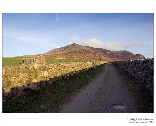
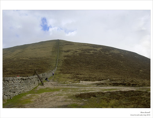
Starting out on the Carrick Little track heading for Slieve Binnian
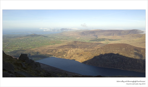
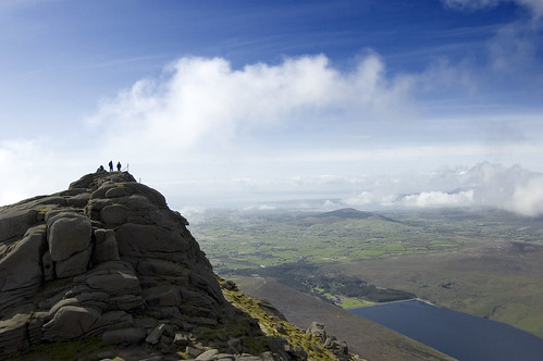
There are a number of places from which to start the walk but I chose the car-park at Carrick Little. From there, a short walk along a track brings you to the wall itself which offers a sure guide almost to the summit of the mighty Slieve Binnian, halting only when it reaches the summit Tor where it is replaced for a stretch by a wire fence. With a height of 747 metres and a height-gain of around 580 metres from the car-park, Binnian represents the perfect pulse-raiser. The summit proper is atop the impressive Tor and you’ll need to grapple with some rock should you wish to reach it. At 7am, I had the summit all to myself but dwelt there just a short while to admire the magnificent views down onto Silent Valley below as well as North-West across to some of the mountains I would climb later in the day including Meelmore, Meelbeg and Loughshannagh.
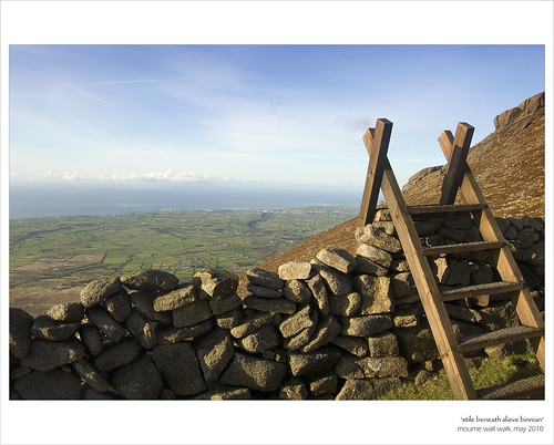
A stile crosses the wall close to the summit of Binnian
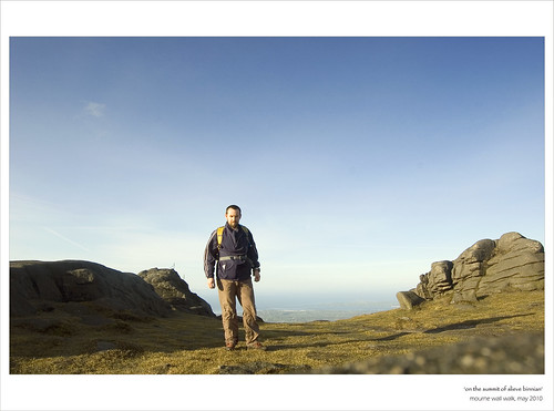
Brief stop at the summit of Binnian

View from Binnian across to Loughshannagh, Meelbeg and Meelmore
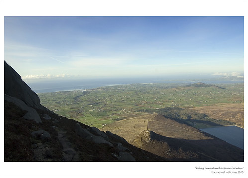
Looking down at Wee Binnian from Binnian

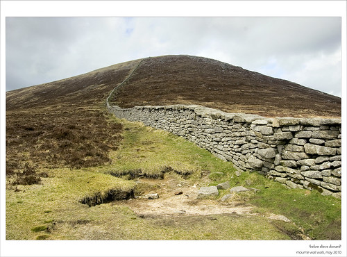
The wall running from Slieve Binnian to Wee Binnian, Doan in the background
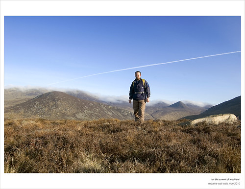
On the summit of Moolieve, Slievenaglogh to the left
The descent down Binnian is over some very steep ground and you need to take care to avoid the slabs immediately below the Summit Tor. The wall passes over the summit of Wee Binnian but this can be bypassed through the notch to the left. The minor summit of Moolieve is next before you lose all of the height you gained by following the wall down to the reservoir at Silent Valley. As I crossed the reservoir and glimpsed up at Slievenaglogh towering over the water, apprehension set in. The stretch from Silent Valley to the summit of Muck had proved troublesome on my last effort albeit in more difficult conditions.
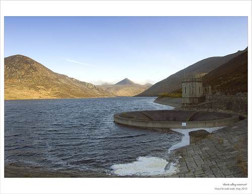
Crossing the Silent Valley reswervoir, Slievenaglogh is to the left
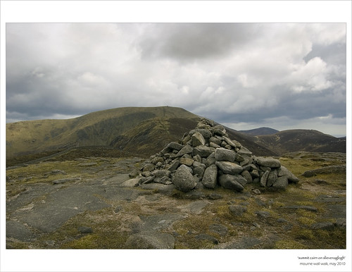
On the far side of the reservoir, turn right at the shelter and follow a track uphill. At the bend, leave this track to follow a vague path uphill through some wet ground and thick vegetation. Cross the fence at the top of this path and follow it up to the wall. This section of the walk is particularly boggy but the wall avoids the worst of the bog by continuing uphill before taking a ninety degree right turn to head for the slopes of Slievenaglogh. Take it from me that you are best advised not to give into the temptation to take a short cut through the bog. The climb up Slievenaglogh is steep in places across some bouldery ground but with a bit of care, a decent path can be picked to the summit of the mountain at 445 metres which is marked by a summit cairn. From the cairn, the path across to Slieve Muck is clearly visible.
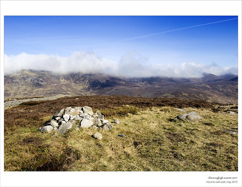
Summit cairn at Slievenaglogh
Looking North towards Ben Crom from Slievenaglogh
Cross the wall to descend Slievenaglogh over some more very steep ground. A track leads from the bottom of the mountain across Banns Road before veering away from the wall to pass through a gap in a subsidiary wall. Veer back towards the wall and follow it up the relentlessly steep and seemingly never-ending steep slopes of Slieve Muck. There are a couple of points where the ground becomes too steep even for the wall and it gives way to slabs. You will need to steer to the right of these sections.
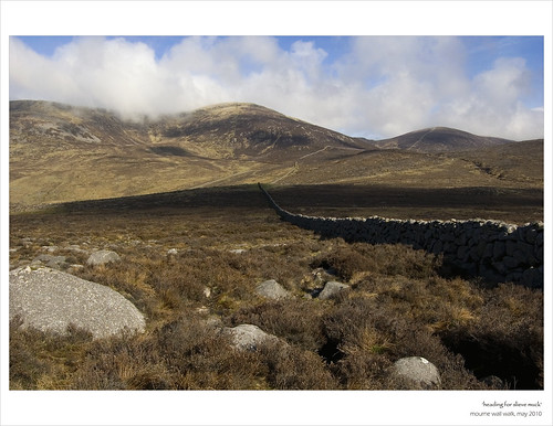
Heading for Slieve Muck
It was towards the top of Muck that I felt the first slight twinges of cramp in my legs but these were eased somewhat when the steep slopes gave way to gentler ground leading to the trig pillar on the summit plateau. It was a huge relief to reach this point of the walk so early in the day and with already over half the total ascent done, I could now look forward to tackling the sections of the walk which were new to me in the knowledge that most of the hard work was now behind me.
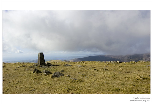
Trig pillar on Slieve Muck with the Cooley Mountains to the background
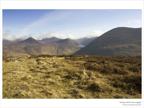
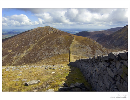
The section from Muck along Carn, Loughshannagh, Meelbeg and Meelmore is relatively straightforward with the height gain and loss between each mountain being small compared with that between Binnian and Muck. What I hadn’t anticipated was the cramp in my legs that was to arrive sharply and sporadically throughout the rest of the walk particularly during the ascents. The stone lookout tower on the whale-back bulk of Slieve Meelmore is an obvious landmark but the actual summit is marked around 100 metres away by a stone cairn. What is very striking along the stretch from Meelbeg to Meelmore is just how steep the section of the wall running up Slieve Bearnagh is – it really looks a preposterous and impossible angle from certain viewpoints.
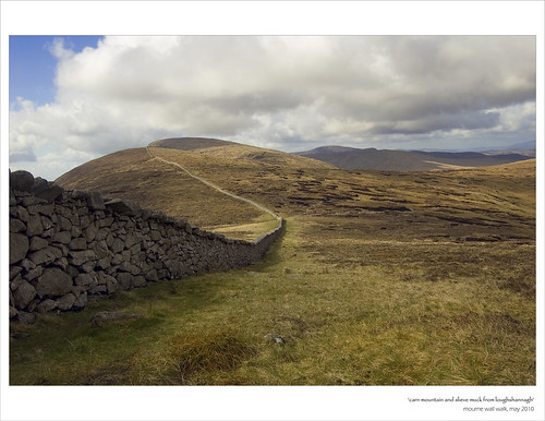
Looking back at Carn and Muck from Slieve Loughshannagh
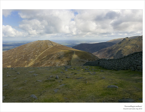
View from Meelbeg to Meelmore - the steep wall climbing Bearnagh can be seen to the right
The impressive bulk of Slieve Meelmore
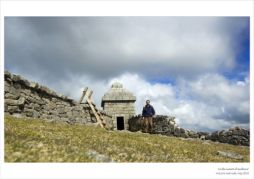
At the lookout tower at Meelmore
The best method of climbing Bearnagh is to keep well to the right of the wall where the incline is somewhat gentler before picking your way upwards. I had by now adapted a pretty erratic zig-zag style of walking uphill, taking four or five lateral steps for each step upwards. By the time I reached the top of Bearnagh, I had adapted something of a ‘Basil Fawlty’ style funny walk and with quite a few people picnicking at the base of Bearnagh’s impressive summit Tor, I decided it would be best not to make an exhibit of myself by attempting to scramble up the rocks to the summit proper.
North Tor, Slieve Bearnagh
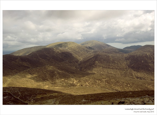
Commedagh, Donard and the Brandy Pad from the slopes of Bearnagh
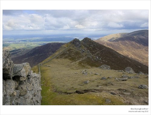
The wall continues across Bearnagh via a couple of smaller Tors which can be bypassed over a distinct path before dropping down to Hare’s gap. The gap was a hive of activity with people of various nationalities consulting maps and making plans for the day ahead. I on the other hand had the finish line in sight and only had eyes for the last stretch of mountains ahead running from Slievenaglogh across to Ulster’s highest point, Slieve Donard via Slieve Corragh and the mammoth bulk of Slieve Commedagh.
The steps leading from Hare’s Gap up the initial steep section at the foot of Slievenaglogh were sheer torture and I was glad when a man and his son stopped briefly to discuss the black clouds that were approaching as well as the man’s deep-held physicological fear of Slieve Bearnagh after he had come to an abrupt stop halfway up it's relentless slopes on a previous assault. I was that busy concentrating on not blowing-up myself that I completely missed the ‘Diamond Rocks’, a crystalline outcrop of granite on the ascent to the summit cairn on Slievenaglogh. By the time I had crossed to the unassuming Slieve Corragh, I reckon I probably looked much like an unwanted extra out of a low-budget 1950’s war-film. Luckily this section of the wall doesn’t attract much walker traffic so my continuous utterances about ‘only 2 more left’ went unheard. The views from Corragh are arguably amongst the best along the walk with Slieve Bearnagh towering over the impressive Ben Crom Reservoir providing a spectacular backdrop.
Summit cairn, Slievenaglogh
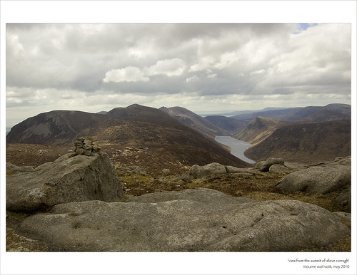
View from the summit of Slieve Corragh across Ben Crom Reservoir
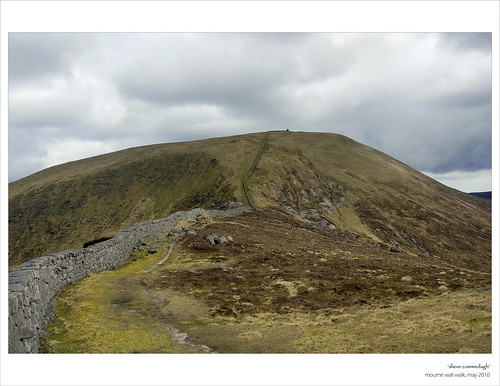
Looking ahead to Slieve Commedagh
It was on the ascent of Slieve Commedagh that the heavy black clouds finally made their move, streaming across Commedagh before depositing a heavy shower of hailstones over the mountain. Surely, only the mountains can delivery all four seasons within the space of a couple of hours. My pace of ascent had slowed to a crawl up Commedagh and the digits on my GPS counting down the distance to the summit seemed to be moving with the same lethargy as myself. I had now taken on a ‘boom and burst’ method of walking, pushing myself hard for 10 seconds before stopping for a prolonged rest. When the lookout tower finally emerged from the clouds at the summit of Commedagh, I only had one more mountain to climb, albeit the highest of the day.
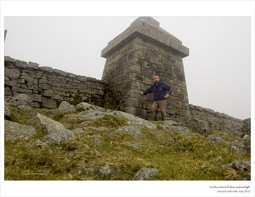
Lookout tower on Slieve Commedagh. Me being held up by the wall!
The final climb up Slieve Donard - looks quite simple in this photo
I dropped out of the cloud down to the broad gap between Commedagh and Donard. Again, groups of people were gathered at the gap whilst others were at varying stages of ascending and descending both mountains, those close to the visible only as tiny dots. Buoyed on by the sight of my last summit, I made good progress upwards stopping occasionally to speak to people taking the ‘tourist trail’ up the mountain including one man in his fifties who lived within sight of Donard but who had only climbed the mountain for the first time that afternoon. He told me that he had proudly phoned his son in Australia from top of Donard to break the news to him. Slieve Donard was the first mountain I ever climbed and I had been taken by the impressive views both out to sea and across the rest of the Mournes. On a clear day, views reputedly stretch to the Wicklow Mountains as well as across to the Isle of Man.

A ray of light catches the gap between Commedagh and Donard
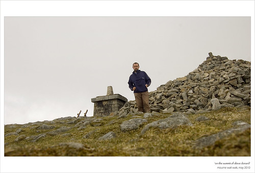
On the summit of Donard.. exhausted
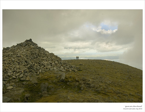
The Great Cairn on Slieve Donard
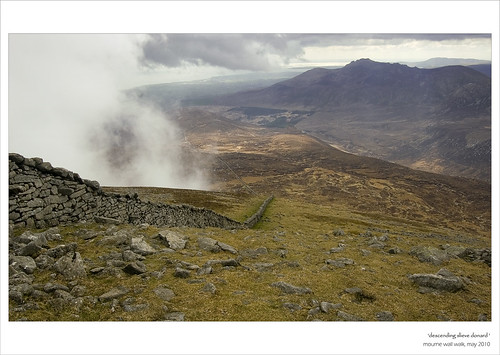
Descending Slieve Donard towards the Bog of Donard
If I had any feeling of completion when standing beside the huge cairn that marks Ulster’s summit, it was misplaced. I had not banked on the long descent from the mountain down to the Bog of Donard and over to Long Seefin. After what seemed like an eternity of walking with bits of sporadic running, I finally reached the curious little stone tower below Long Seefin at which point the wall loses its epic proportions. A right turn at this tower takes you down the hill where you have a couple of options as to how to complete the walk. I opted to stick as close to the wall as I could following it down across the Annalong River and up the other side. This proved to be a bad choice; what looked like a short last stretch of the walk through Annalong Woods turned out to be something of a nightmare slog. The section of woods I passed through had been felled leaving thick grass and brambles which were knotted into the hidden remnants of the tree felling, all sitting atop uneven and boggy ground. The conditions underfoot and aching legs made for very slow and frustrating progress and it was a feeling of immense relief that greeted the sight of the track leading back to the car-park at Carrick Little, so much so that I broke into a jog back to arrive at the car-park some 10 hours and 43 minutes after I had left.
Looking back at Slieve Donard from the Bog of Donard
The overriding feeling was one of relief, relief that I was finished, relief that I could sit down for a while and most of all relief that I had laid to rest the ghost of eight months previous. I had hoped to complete the walk in sub 10 hours but the struggle through Annalong Woods on exhausted legs had greatly eaten into my time. Along the 35km, I had fallen out with the wall on numerous occassions as it stood idly by watching dispassionately as I was seized by cramp and rendered immboile. At several stages, I had vowed never to visit it again but deep down I was full of admiration for it and knew that sooner rather than later I’d be back again walking alongside it. Most of all, I spent my time in a state of wonder and amazement at the amount of human effort, sweat and tears that must have been expended in building this amazing, unprobable and magnificent structure.
The walk really is a superb way to experience the Mourne range. The wall itself makes the mountians very accessible and navigation very easy. The circuit of the wall should not however be underestimated, the height gain and section as far as Slieve Muck in particular representing a very tough challenge which requires more than a decent level of fitness.
For me the main thing was not that I had fallen, it was that I had got back up again!
Congratulations on a lovely site jason and a fine walk. I finally finished my last "Dillon" just yesterday (Paps East top). All 212 finally done. I planned to do them in 3 years...It took me 16 years- but I've met great friends, and had some magnificent times- bagging.
ReplyDeleteBernie mahon
(Due to my obsession, my friends have ended up calling them the "Bernies" as I went off and left them to bag odd hills.)
Hi Bernie,
ReplyDeleteCongratulations on that achievement! Are you planning to do a write-up of your efforts?
Paul
Surely you burnt more than 1800cal?
ReplyDeleteHi nice reading youur post
ReplyDelete